More Info
All the Details -- Site Features, Community Compatibility, and More
This page is a work in progress!
We will continue to update it with studies, research findings,
statements from subject matter experts, and other relevant information in real-time.
3/25/26: A discussion of site conditions and summary of previous studies compiled from the attachments below,
our 2024 RFP response, and discussions with subject matter experts over the past two years.
3/22/26: Draft wildlife management plan, developed with the support of the Department of Fish & Game, coming soon.
10/28/25: HLB commissioned a geotechnical subsurface investigation
to ensure conditions are suitable for natural burial. Though there are some limited areas with shallow soil depths,
the majority of the parcel appears to support our vision.
From the archives 7/31/24: View our response to
Heritage Land Bank's Request for Proposals regarding Parcel 2-156.
An immense effort has gone into bringing our vision for Alaska Natural Burial to fruition. This page gives a birds-eye view of our site selection process and then takes a deep dive into some of the information we've gathered along the way.
Site Selection
Our site selection process was a lot like finding a needle in a haystack. First and foremost, it was important that the site we chose was in need of active conservation efforts and that those efforts could be facilitated through the operation of a Conservation Burial Cemetery. Also important were the specific site features (eg., geological, hydrological) as they needed to be conducive to natural burial. Heritage Land Bank Parcel #2-156 checks all of the boxes that matter.
And it came with a bonus -- a treasure trove of information in the form of commissioned studies conducted over the past 50 years as various development efforts were attempted. It means we already have a really good idea of the soils, slope, and hydrological features that we'll encounter on Parcel #2-156. Parcel #2-156 is contiguous with approximately 300 acres of urban forest, sandwiched between Potter Marsh and Goldenview Drive in south Anchorage. This urban forest serves as an important wildlife corridor between the Chugach Mountains and Potter Marsh. Just over a half mile away from the marsh (and several hundred feet of elevation higher) the soils of Parcel #2-156 are well-drained, consisting primarily of glacial till. The hillside slope is described as gently undulating (0-12%) though there are certainly steeper areas that exceed this. There are no underground aquifers beneath the property, nor are there any wells downhill from the property. There are no wetlands, streams, or other surficial waterways on Parcel #2-156. The land is not prone to flooding.
Because housing is such a concern within the Municipality, it's worth mentioning that this parcel is not well-suited for residential development. Numerous attempts have been made in the past. It is cost-prohibitive to bring in the infrastructure (e.g., roadways, utilities) to support such a development. The extent of disruption to the existing ecosystem, especially with the amount of impermeable surfaces, would likely have a negative impact on water runoff patterns and on the wildlife corridor. In 2025, Anchorage's Parks & Rec began their master planning process for the Potter Marsh Watershed Park -- to conserve the approximately 300 acres of urban forest contiguous to Parcel #2-156; conserving Parcel #2-156 as a Conservation Burial Ground ensures that the land will remain wild for generations to come.
We have had countless conversations with USDA soils scientists, wildlife biologists with ADF&G, arborists, local funeral home professionals, landscape architects specializing in municipal and cemetery projects, the area community council, and many other members of the community. At the end of the day, we're all about following the data. We believe this project is a win-win for the community and for the perpetual conservation of this parcel. As long as the data continue to support the merits of this project, we plan on forging ahead.
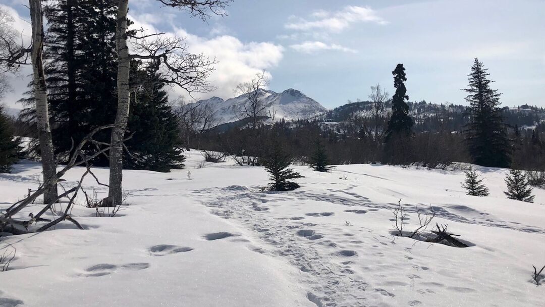
Early spring at Parcel 2-156
Below you will find:
- links to previous site studies dating back to the 1970s
- links to current regional, district, and neighborhood plans, and related projects, including a white paper speaking to the shortage of cemetery space in Anchorage
- a collection of other information, including info on wildlife encounters and on cemeteries as a source of pollution
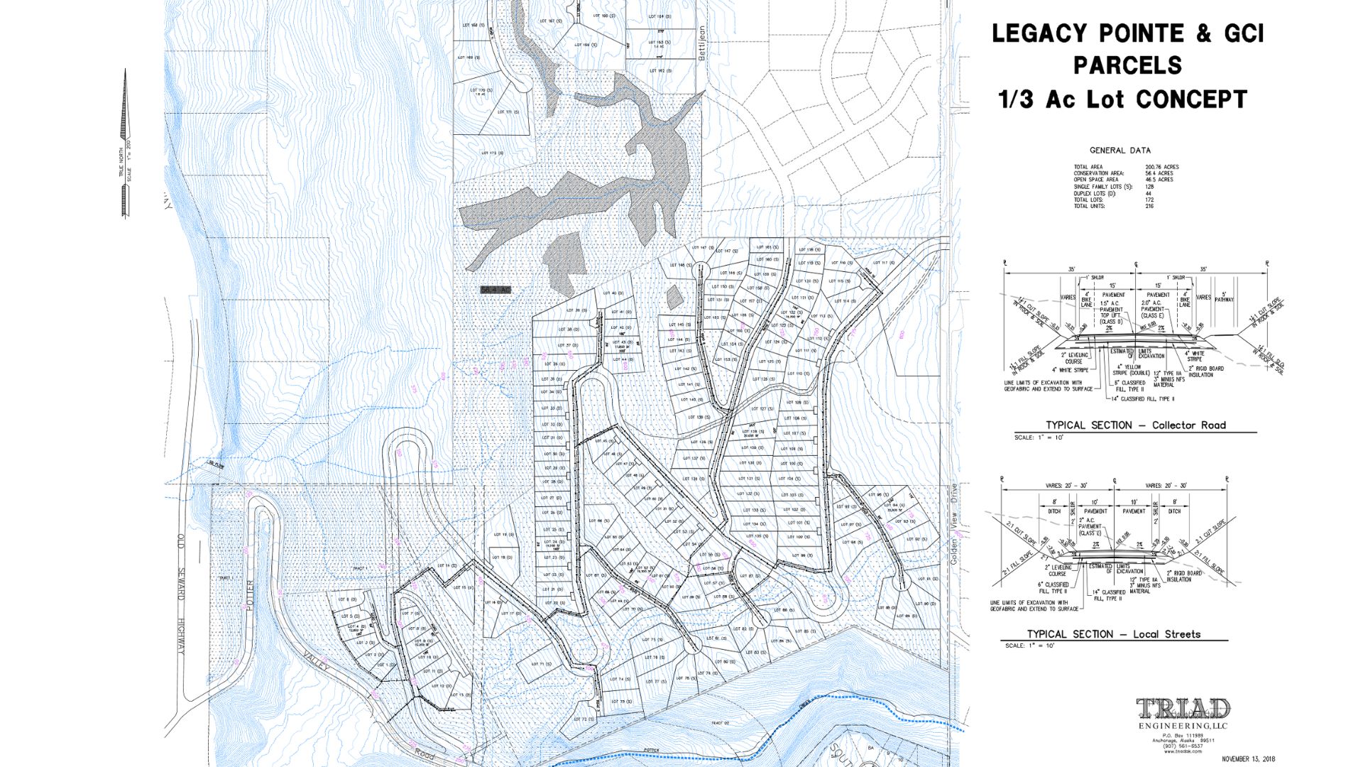
Triad Engineering documentation pertaining to a proposed subdivision. Includes detailed information about financial and environmental barriers to development, especially for the collector road and to bring utilities to the parcels.
- 2018 Subdivision Final Analysis: Development Analysis Tract 1 Viewpoint Subdivision
- 2018 Subdivision Preliminary Comments: Detailed information for planning Legacy/GCI tracts proposal
- 2018 Subdivision Collector Road Concept
- 2018 Legacy 0.3 acre lot concept
- 2018 Legacy 0.3 acre lot cost estimate
- 2018 Legacy 0.3 acre concept estimate notes
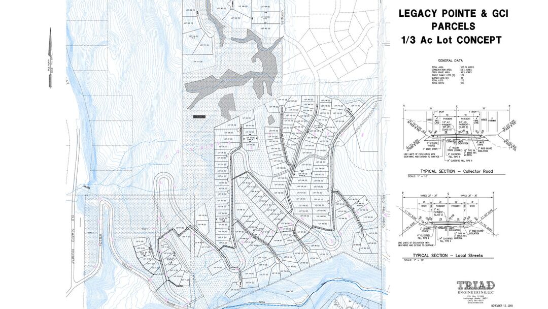
2018 concept map of subdivision
Property descriptions of the large hillside parcels between 2013 - 2015, in the context of a potential consolidation.
- 2014 Memo re Potter View Disposal Scenarios
- 2013 Plat of Legacy Pointe Tracts B1 & B2 (including HLB Parcel 2-156)
- 2015 Property Info re ARDSA consolidation
- 2015 Map re ARDSA Consolidation
R&M Consultants and correspondences related to the 2012 division of an HLB parcel with the north portion going to AWWU and southern portion becoming what we now refer to as HLB Parcel 2-156
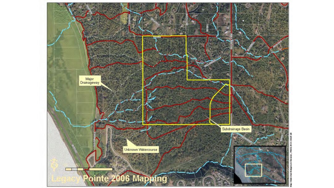
2006 mapping of subdrainage basins

1998 - 2002 appraisal and studies 1983 Zoning and Muni soils log from test sites along Goldenview Drive Soils study from 1977
Here are the relevant regional, district, and neighborhood plans, and related projects:
- 2006 Anchorage Bowl Park, Natural Resource, and Recreation Facility Plan 2006
- 2010 Hillside District Plan
- 2000 Anchorage Bowl Comprehensive Plan (links to website) 2000
- 2019 Anchorage Climate Action Plan
- 1999 Potter Valley Land Use Analysis
- 2014 Anchorage Wetlands Management Plan
The Potter Marsh Watershed Community Forest is a plan to conserve the approximately 300 acres of urban forest next to Parcel #2-156. Once complete, the project will be owned and managed by the Municipality of Anchorage and Great Land Trust will hold a conservation easement on the land.
- The Potter Marsh Watershed Park master plan is here: https://www.muni.org/Departments/parks/Pages/PMWP.aspx
- September 2024 update from Great Land Trust
- 2023 Potter Marsh Watershed Community Forest Narrative
- 2023 Potter Marsh Watershed Community Forest Numbers
Letters of support:
White papers and other opinions:
- ADF&G's response and attached article addressing concerns about wildlife (especially bears) disturbing graves
- Anchorage Memorial Park White Paper